MSc in River Basin Dynamics from the School of Geography
I have pursued an MSc in River basin Dynamics and Management with GIS from the School of Geography, University of Leeds, United Kingdom. This course is highly significant for environmental management particularly flooding in the UK and other parts of the world in the present scenario of climate change. The modules I learnt such as GIS and Environment, Data Visualisations, Hydrological processes and analysis, Digital Image Processing for Environmental Remote Sensing, Water Quality and 60 credits Dissertation are relevant to deal with current environmental issues. My GIS and flood modelling skills using ArcGIS, QGIS, Flood Modeller, HEC-RAS along with theoretical knowledge of data processing and flood management helped me to develop the potentials to conduct a research studied and I aim is to utilise those skills and subject knowledge in my PhD to do a quality research in the domain of Himalayan hydrology.
This degree also opened the door for me to develop academic network in Europe and beyond through attending seminars, workshops and presenting papers at conferences [details]


From top left to bottom right: Parkinson Building, School building, GIS cluster, School of Geography, with Dr Duncan Quincey (Dissertation supervisor), with Dr Jonathan Carrivick, MSc Thesis.
MSc Dissertation
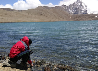
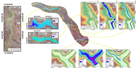
As a part of the MSc degree, I did my dissertation on the 'Glacial Lake Outburst Flood (GLOF) risk assessment in the Teesta River Basin of Sikkim Himalaya, India' using GIS based Monte Carlo Least Cost Path (MC-LCP) method and physically based spatially distributed HEC-RAS 2D flood modelling approaches. During this time, I also conducted a fieldwork in the eastern Himalaya to survey some of the selected lakes with the funding from the Priestley International Centre for Climate (PICC).

Figure: Study area location
Abstract
Glacial lake outburst flood (GLOF) is one of the most gigantic natural hazards in the Himalayan region which poses a significant threat to downstream communities and infrastructures. In the Eastern Himalaya, Teesta River Basin is known as the zone of all possible natural hazards (e.g. GLOFs, Flash floods, Landslides etc). This study has been attempted to assess the potential risk of GLOF in this basin using two flood modelling approaches viz. GIS based Monte-Carlo Least Cost Path (MC-LCP) and Hydrologic Engineering Center-River Analysis System (HEC-RAS). An effort has also been made to integrate 25 years (1990-2015) climate data in to this study for understanding the role of climate change to GLOF. The investigation highlights that 203 new lakes were developed within the observation period (2000-2018), out of which, 82 lakes (40%) developed in the last decade (2011-2018) which indicates an alarming rate of glaciers retreat and lake growth. Based on a wide range of hazard assessment parameters, 36 hazardous lakes were identified, among which 7 lakes were considered further for GLOF risk assessment. MC-LCP modelling output shows that each of these hazardous lakes inundate a significant amount of area and has the potential of huge socio-economic impacts including loss of life and property. For example, Phunri Lake (EHS_UT_015), the source of Teesta River with the possibility to inundate 16.8 km² of total area, damage 205 buildings, 1025 people and 31.8 km of road is posing high risk of GLOF along with lake EHS_UT004 and EHS_UT_056; while another three lakes (e.g. EHS_UT_085, EHS_UT_096 and EHS_LC_018) are of medium risk and EHS_LC_010 is the only lake posing low GLOF risk to the downstream communities. This first-pass MC-LCP technique was evaluated with HEC-RAS 2D modelling and it has been shown that this newly developed method is highly useful to produce an acceptable flood inundation extent mainly for the data poor Himalayan region. This study also suggests the future possibility to use this method as a robust flood inundation approach with fine resolution Lidar imageries and DEM data to conduct more accurate and continuous monitoring of glacial lakes and to develop a sophisticated GLOF early warning system to save lives and properties.
Keywords: GLOF. GIS MC-LCP Modelling. HEC-RAS 2D Modelling. Risk Assessment. Teesta River Basin.


Figure: Dissertation fieldwork in North Sikkim of Eastern Himalaya and the modelling output.
Two-days fieldwork at Yorkshire Dales
During the first semester, we had a two days fieldwork in the Yorkshire dale region as part of the 'Issues and skills of river basin dynamics and management' module. The first day of the fieldwork was to collect invertebrate and other samples (e.g. water temperature, pH, river discharge data etc) from the selected five sites of river Wharf, whereas, the next day was involved in fluvial geomorphological measurements (e.g. water depth, discharge, velocity etc), observations of channel characteristics, floodplain, interactions between channel vegetation, river bed and river bank and various Natural flood Management (NFM) implementation for flood mitigation in the Coverdale catchment.
All the data collected from the field were gathered and distributed to the individual students after pre-processing for further analyse to prepare the stream ecology report for the module. There was also a group presentation based on the field observation to identify the effective flood management measures. Our group highlighted some key issues we have observed in the field and revealed some innovative ideas for the upland flood management which were highly appreciated by the tutors. This fieldwork was very helpful to develop the understanding of hydrological and ecological processes in the fluvial systems and also to enhance our fluvial geomorphological understanding.


Figure: Fieldwork in Coverdale for invertebrates sample collection and geomorphological surveying followed by the laboratory work.
Water Quality fieldwork at Ingbirchworth catchment
Yorkshire Water has four reservoirs in the the Ingbirchworth catchment: Royd Moor and Broadstones which feed into Ingbirchworth (used for drinking water) and Scout Dyke (a compensation reservoir). Scout Dyke is popular for recreational fishing and at times during recent years has experienced quite severe problems with algal blooms, as has the Ingbirchworth reservoir. The high concentrations of nitrate, phosphate and ammonium are probably contributing to algal growth, although recent monitoring highlighted that concentrations have fallen in some streams, , possibly due to Nitrate Vulnerable Zones legislation and Catchment Sensitive Farming advice. To develop better understanding and address the issues such as the land use impacts on water quality, assessing and identifying available and possible measures to farmers and land managers to mitigate these impacts, we conducted a fieldwork in the Ingbirchworth catchment during our second semester as part of the River basin management for water quality module.
After spending the whole day in the field to collect water sample from ten different sites of these two reservoirs to measure the concentrations of nitrates, phosphates, ammonium, pH for water quality assessment in the laboratory and based on the field observation for available best management practices (BMPs), we produced individual reports. In my report, I highlighted some of the effective available measures (e.g. buffer strips) and advised possible BMPs (e.g. frequent replacement of the tramlines in the field, selection of specific manure and livestock storage sites etc) for the catchment management based on the Water Framework Directive (WFD) regulations to achieve the directive's water quality standards.


Figure: Water sample collection from Ingbirchworth and Scout Dyke reservoirs for water quality assessment and catchment management.
University of Leeds Library
University of Leeds has total five libraries with outstanding facilities and huge collections of books, published journals and online resources. Out of these five libraries, fours are on campus, viz., Brotherton, Edward Boyle, Laidlaw, and Health Sciences Library. Apart from the libraries, there are two public galleries are also available on campus which display rare items and artworks.
Besides the libraries, there are twelve IT clusters are available in the campus which are accessed 24 hours with specific code and each school has its own clusters, reading rooms and laboratories. School of Geography has two dedicated and smart GIS clusters for the geography students for 24 hours access with the special fob (key). These GIS clusters were my second home in the UK during my study where I literally spent more time than my accommodation. I also used Edward Boyle Library which is mainly famous for science students and I usually studied at level 13 which is mainly accessible for the postgraduate taught and research students.


From top left to bottom right: Inside of Edward Boyle Library; Laidlaw library; Inside of Edward Boyle Library; Edward Boyle Library building, on my seat at GIS cluster after with MSc degree, Reading Room.